
A marine relief 280 meters high and more than six kilometers wide, excavated from the ocean floor some 550 million years ago, emerges today on land in the Flinders Ranges of South Australia. A new study reconstructs those ancient underwater canyons and raises an uncomfortable idea: What we know about early complex animals depends both on where they lived and what landscapes geology chose to preserve.
An ancient seabed that is now a mountain
The rocks of the Flinders Ranges hold the fossil record of the Ediacaran, the period that precedes great animal diversification and in which some of the oldest known complex organisms appear. Between these layers is the Ediacaran Membera unit of the Rawnsley Quartzite famous for preserving impressions of soft-bodied beings that, under normal conditions, leave no fossil trace.
The work is signed by Karol Faehnrich, Diego C. García-Bellido, Mary L. Droser, James G. Gehling and Robert R. Gaines, and was published as an original study whose dissemination was carried out by the University of Adelaide in November 2026. Their contribution is not a new fauna, but a different reading of the scenario: beneath these fossil deposits there are deep valleys with canyon geometry, interpreted as submarine canyons facing southeast.
Erosion, flooding and filling: the sequence proposed by the study
The reconstruction is based on what the rocks record, not on an imagined scene. The authors mapped a regional surface of erosion and valleys at the base of the Ediacara Member, and found a telltale fill: thick breccia, deposits associated with gravitational flows and deep-water siltstones. They are materials compatible with underwater erosion, downslope sediment transport, and accumulation in deep marine environments.
Based on this evidence, the study proposes a sequence in three acts. First, a relative drop in sea level that would have initiated the incision of large valleys in the continental shelf; The authors even contemplate that some areas eroded above sea level before being submerged. Then, a rise in the sea that flooded those canyons. And finally, underwater currents and gravity flows that dragged sediments into the depressions until they were filled.
Simplified timeline of the process
- 1. Erosion: Falling sea levels carve large ancient underwater canyons into the continental shelf.
- 2. Flood: The sea rises again and quickly covers those valleys with deep water.
- 3. Filling: Currents and gravitational flows deposit breccia and siltstones that bury the bottom, including the tracks of soft-bodied organisms.
It is advisable to stop at a figure that can be misleading. The 280 meters They describe the depth of the preserved canyons, that is, the geometry of the erosional relief. They don’t measure how much sea level has dropped. The study speaks of a significant drop as a trigger for erosion, but does not equate this drop with the 280 meters of the canyon. Transforming a landscape dimension into a measurement of sea level change would be a misreading.
Why a canyon that fills quickly can preserve a soft animal
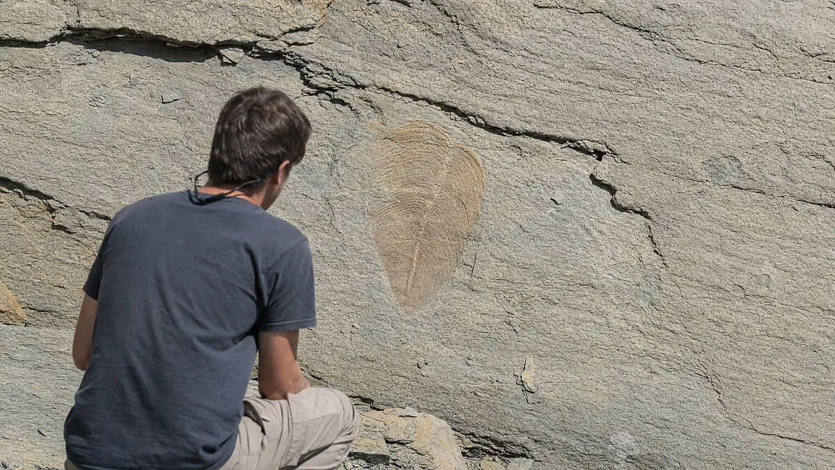
This is where the connection between geology and fossils comes in. When the sea rose again and flooded the canyons, the sedimentary fill was able to create favorable conditions for rapidly burying bottom surfaces, including impressions of soft-bodied organisms. According to lead author Karol Faehnrich, rapid flooding as the sea rose helped preserve the fossils; His co-author Diego García-Bellido describes this rise as the origin of an exceptional conservation “window” for the delicate traces of beings without hard parts.
Nuance matters: the study does not claim that the cannons were the only preservation factor. He reconstructs the landscape and proposes that its filling created environments conducive to the fossilization of soft organisms. Actual fossilization further depended on sedimentology, sediment chemistry, burial rate, water energy, and subsequent history of the rocks. Landscape is one piece of the puzzle, not the entire answer.
The fossil record as a selective window, not as an inventory
This is the idea worth taking away. An underwater canyon is not a simple container that receives sediment: it also filters which organisms, what sizes and what communities are likely to be buried. The layers accessible today may represent specific environments—channels, banks, flow zones—and not the entire Ediacaran ecosystem.
What’s left out, then? Communities that lived in bottoms less favorable for rapid sedimentation, or whose rocks never emerged, may be underrepresented in the catalog we manage. The known record depends on two things at once: where the fauna lived and where its rocks were preserved and exposed. Exceptional preservation, paradoxical as it may seem, can also conceal.
Added to this geological filter is another, typical of this type of fossils. Many of these pieces are impressions: they preserve the external shape of the organism, not its tissues or internal anatomy. In fronds, for example, often only the attachment base is preserved, leaving identification open. An extraordinary fossil layer continues to have preservation biases.
What the study observes and what it leaves open
Separating what is observed from what is proposed avoids turning a hypothesis into certainty. The study observe an erosion surface, canyon-shaped valleys and a fill of breccia, gravitational flows and deep siltstones. From there proposes a sequence of lowering of the sea, flooding and filling, and suggests that this process helped generate conservation conditions.
What is not closed is not minor either. It is not quantified here exactly how much the sea level fell, nor the precise proportion between underwater erosion and possible erosion above water, nor the exact speed of the flooding, nor how much the canyons weighed compared to other factors in fossilization. These are uncertainties that the approach itself recognizes as it is a paleogeographic reconstruction, not a test of a single cause.
The next time an illustration shows a seabed populated by Ediacaran creatures, it is worth remembering that the image is drawn on the rocks that survived. The ancient landscape not only hosted life: it also decided, in part, what fragments of it we could read 550 million years later. How much of what we call “the fauna of an era” is, in reality, the map of what geology wanted to keep?